


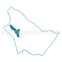
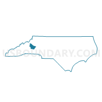
Voting District 0020, Burke County, North Carolina
About
Outline

Summary
| Unique Area Identifier | 639470 |
| Name | Voting District 0020 |
| County | Burke County |
| State | North Carolina |
| Area (square miles) | 15.57 |
| Land Area (square miles) | 13.82 |
| Water Area (square miles) | 1.76 |
| % of Land Area | 88.71 |
| % of Water Area | 11.29 |
| Latitude of the Internal Point | 35.78209870 |
| Longtitude of the Internal Point | -81.85125520 |
Maps

Graphs
Select a template below for downloading or customizing gragh for Voting District 0020, Burke County, North Carolina


Neighbors
Neighoring Voting District (by Name) Neighboring Voting District on the Map
- Voting District 0019, Burke County, NC
- Voting District 0047, Burke County, NC
- Voting District 0051, Burke County, NC
- Voting District 0062, Burke County, NC
Top 10 Neighboring County Subdivision (by Population) Neighboring County Subdivision on the Map
- Silver Creek township, Burke County, NC (10,793)
- Quaker Meadows township, Burke County, NC (7,339)
- Linville township, Burke County, NC (1,761)
- Upper Creek township, Burke County, NC (1,180)